Passo della Teglia - Carmo di Brocchi - Passo della Teglia


elevation profile
Distance: 5.19 km
Time: 3½ – 4½ hours
Ascent: 484 m
Data on the hike
The starting point for the hike is Passo Teglia.
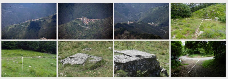
If you are coming from Molini di Triora to the pass, the hiking trail branches off to the left of the road; if you are coming from San Bernardo di Conio or Rezzo, it branches off to the right (Fig. 1). Follow the narrow path uphill and along the very steep slope (Figs. 2, 3). At the beginning, the very narrow path leads through dense hedges and is sometimes difficult to see. Soon, the view opens up into the valley. After about 1.9 km, you will reach the foot of Carmo di Brocchi (Figs. 3, 4). Here, turn left and follow the very narrow path steeply uphill through the grassy slope (Figs. 4, 5). Be careful, as wet grass can be very slippery. After a steep climb of 440 m, you will reach the summit of Carmo di Brocchi (Figs. 6, 7). From here, you have a magnificent panoramic view of the valley towards Andagna, Molini di Triora, Triora and Corte (Figs. 8, 9, 10, 11).

The descent is via the narrow, very steep path that you took for the ascent. There is an increased risk of slipping on the path, which is mostly covered with grass. Once you reach the bottom, turn left into the forest (Fig. 11), follow the path downhill and you will come to an open area, which you cross. You will come to a path which you follow to the right through the forest (Fig. 13) and soon reach an open area. On the right-hand side, you will see a deep hollow at the foot of Carmo di Brocchi. Standing at the edge of the hollow, you can see a very old sacrificial table a short distance away on the sloping hillside (Figs. 14, 15).
Now follow the path through the forest, past a memorial stone erected for a man who died while hunting. After about 2 km, you will reach Passo Teglia.
panoramic image

PDF file for download