Pantasina - Prelà - Dolcedo - Santa Brigida - Bellissimi - Valloria - Villatalla - Pantasina


Elevation profile
Distance: 27.9 km
Time: 9½ hours
Elevation gain: 1,129 m
Hike details
The starting point of the walk is the church square in Pantasina.
Walk along Via Santuario (arrow in Fig. 1) for about 150 m, past the Azienda Agricola Pino. After a few metres, turn left into Via Lascaris and immediately (after approx. 10 m) right into Via Giuseppe Mela (arrows in Figs. 2 and 3). Follow the road past the small church of San Giuseppe (Fig. 4), keep left at the fork in the road (Fig. 5), and continue slightly downhill until you come to a group of houses (Case Galli). There, keep right (Fig. 6). Follow the path to the church of San Damiano (Fig. 7). Pass the church (Fig. 7), keep to the right and follow the path downhill through olive groves. After a short distance, the path leads briefly through a deciduous forest. Immediately after the forest, a narrow path branches off to the left (Fig. 8). Follow the narrow path downhill (Fig. 9) through olive groves. Between the trees, you will occasionally catch a glimpse of Praelo and the valley stretching as far as Dolcedo. After about 30 to 50 minutes, you will come to the provincial road (Fig. 10). Turn right onto the road to Canneto Soprano (Fig. 11).
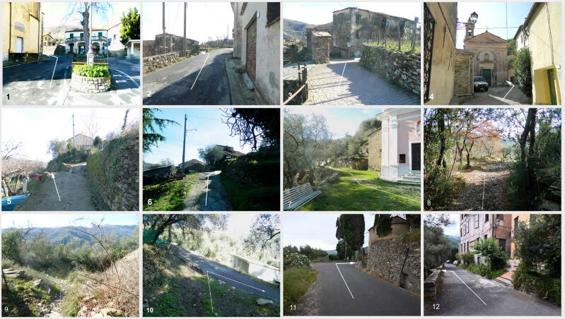
Walk through Canneto soprano until just before the village square, turn left (Fig. 12), go down the steps, pass the Church of San Antonio (Fig. 13) and follow the narrow path to Canneto sottano. Walk through the village and follow the road straight ahead for a while, leave the village and continue downhill. You will reach Molini di Prelà; turn right and go down the steps to the right (Figs. 14, 15). You will come to the main road in Molini di Prelà; turn right and walk along the provincial road past a factory building until you reach a bridge, cross it and turn left immediately after the bridge (Fig. 16). Continue straight ahead (Fig. 17); after a few hundred metres, slightly uphill, turn left onto an unpaved track (Fig. 18) and follow this track until you reach Ripalta. Follow the road downhill (Figs. 19, 20) and turn right (Fig. 21). Pass the restaurant “Casa della Rocca” (Fig. 22) and continue downhill (Fig. 23), cross an old bridge (Fig. 24), turn left and follow the road (Figs. 25, 26, 27, 28).
Behind the archway (Fig. 28), take a sharp right. Follow the road, which is steep in places (Figs. 29, 30, 31, 32, 33, 34, 35, 36). Between the houses, you will have lovely views of Ripalta to your right from time to time (Fig. 34). You will reach Castellazzo. Climb the steep road through Castellazzo, past the church, and you will come to the provincial road leading from Dolcedo to Bellissimi and on to Santa Brigida (Figs. 37, 38, 39). Follow the road uphill for a few metres and turn sharply left (Fig. 40). Walk uphill for a few metres, then turn sharply right and continue uphill (Fig. 41).

Follow the path (Via Santa Brigida) uphill (Figs. 42, 43, 44, 45, 46, 47, 48). As you continue uphill, you will come to a tarmac road (Fig. 49).

Continue up the road, passing a few houses, until you reach the provincial road leading from Civezza to Santa Brigida (Figs. 50, 51, 52). On the side of the road opposite the chapel, a path leads downhill to Bellissimi (Figs. 53, 54). Continue down this stony path, passing a wayside shrine (on the left) and an open space (on the right). After a few metres, there is a gap in the hedge on the left (Fig. 55). Be careful not to turn off there, but follow the narrow path, which turns left after a few metres (Fig. 56). After a short distance, you will come to the provincial road leading from Santa Brigida to Bellissimi. Cross the road (Fig. 57) and follow the paved path downhill to Bellissimi.

Pass the church at Bellissimi (Fig. 58) and follow the path (Figs. 59, 60), which is signposted (Fig. 61), towards Lecchiore (Figs. 62, 63, 64, 65, 66, 67, 68). Leave Lecchiore heading towards Laghetti; after about 7 to 11 minutes (Fig. 69), turn right onto a narrow path that leads downhill and then along the stream to Acqua Santa. There, turn right (Fig. 70) and follow the tarmac road, which is steep in places, and follow the signs for “Valloria”. At the fork in the road (Fig. 71), turn left and you will soon reach the Passo della Valle (Fig. 72).

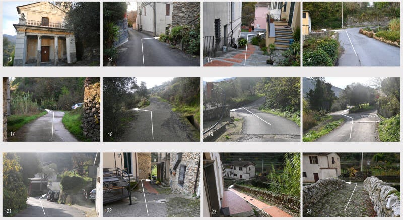
Now follow the path leading to Valloria (Figs. 73, 74, 75), pass a church (Fig. 76), and after a few metres turn left (Fig. 77) and climb the steps (Figs. 78, 79, 80, 81) up to the main square in Valloria. There, turn left and climb a flight of steps; you will reach a narrow alleyway and, after a few metres, turn left (Fig. 83). After more steps and a concrete path (Fig. 84), past an agriturismo, you will soon reach a road (Fig. 85).

Continue uphill, passing the Church of San Giuseppe (Fig. 86), turn right behind the church (Fig. 87), and after a short downhill stretch, turn left onto a path leading to Tavole (Fig. 88). Walk uphill (Figs. 89, 90, 91, 92, 93). You will reach an open space with a chapel (Madonna del Piano) (Fig. 93). Follow the path to the left (Fig. 94), come to the road leading to Tavole, in the Novelli district, and turn left (Fig. 95).

Follow the narrow lane, which leads downhill after a short distance (Figs. 96, 97, 98, 99), and turn left onto a very narrow path bordered by walls (Fig. 100). At the end of the path, turn left (Fig. 101), follow the small road uphill at first, then downhill, turn left (Fig. 102) and reach a square with a church (Fig. 103). Pass the church, continue straight ahead along the road (Figs. 103, 104, 105, 106) and leave Tavole. After a few hundred metres, you will come to the provincial road leading to Villatalla (Fig. 107).

After about 1.8 km, this road crosses a bridge and continues mostly uphill towards Villatalla. You reach the village square, turn left there and head uphill (Fig. 108), then follow the road leading to Pantasina (Figs. 109, 110, 111), pass the Chapel of Santa Marta (Fig. 112), continue climbing (113, 114) and reach the Chapel of San Bernardo at an altitude of approx. 720 m (Fig. 115). There, turn right and descend first along a road, then along a path (Fig. 116), turn right (Fig. 117), follow the path and join the provincial road leading to Pantasina (Figs. 118, 119). Follow the road (Fig. 120) and after about 1 km you will reach the church square in Pantasina.
